Sunday, December 4, 2011

(MS-LA-AR-) Missouri:Taum Sauk


The last stop on our trip was Missouri's Taum Sauk.


The trail is actually very short along a very nicely prepared path, and this is one of few highpoints that specifically brags about it's wheel chair accessibility.


The area is not much more than an hour from St Louis and even closer to the Mississippi river. The highpoint has a plaque on the ground and a boulder marking the spot which I made sure to climb for the feeling that at least a minor effort was exerted during the peak bagging...


Stats:
State: Missouri
High point: Taum Sauk
Elevation: 1 772 ft (540 m)
Date: November 27, 2011
Total elevation to date: 177 933 ft (54 234 m)
Access: Drive-up, short walk, handicap access
Difficulty rating (of 10): 1
Potential Difficulties: Essentially none, except that the look-out tower is not located at the high point but rather a couple of miles away.

(MS-LA-) Arkansas: Mt Magazine (-MO)

Arkansas' Magazine Mountain proved to be the highest and most "mountainy" on this trip. SO much that the weather changed severely when going towards the top with the car, extremely dense fog with barely 30ft (10 m) visibility quickly surrounded us and made way-finding very hard. It did slow us to a crawl in the car though so the chance of accidents was pretty much reduced.

The new state park lodge proved to be a blessing as we decided to stop there for lodging for the night and then hike in the morning instead.


The next morning revealed great views from our room, and the breakfast room seen above was gorgeous. The mosquito net on the windows makes the view look less impressive in the photo below however.


The hike was fairly short and we had no rain although temperatures were fairly low around the freezing point.


There was a limited view from the top of the mountain due to trees, but one could see the valleys below as well as a another peak which looked surprisingly close in elevation.


Stats:
State: Arkansas
High point: Mt Magazine
Elevation: 2 753 ft (839 m)
Date: November 27, 2011
Total elevation to date: 176 161  ft (53 694 m)
Access: hike, class 1
Difficulty rating (of 10): 2
Potential Difficulties: Finding the trail-head (fog!).

(MS-) Louisiana: Driskill Mountain (-AR-MO)

Louisiana's Driskill Mountain was located in the remote areas of the state where churches seem more common than people. Also houses not in the trailer home format are rare and far between...


The weather was not very cooperative, although we did have less heavy rain than what we drove through just half an hour before our hike. The problem though was the soil which consisted of very red clay like material which got very muddy and slippery (and discoloring) when walking in it.


Markus made sure to sign the ledger now that he had successfully doubles his highpoint count in USA (While protecting his backpack full of electronics under his jacket).

Stats:
State: Louisiana
High point: Driskill Mountain
Elevation: 535 ft (163 m)
Date: November 26, 2011
Total elevation to date: 173 408  ft (52 855 m)
Access: Hike, class 1
Difficulty rating (of 10): 1
Potential Difficulties: foul weather...

Missisippi: Woodall Mountain (-LA-AR-MO)

Missisippi's Woodall Mountain was the first stop on a 4-state highpointing spree during the Thanksgiving weekend. The trip also included a visit to Mammoth caves and 2400 miles on the prius odometer together with friend Markus.


Not too much excitement at the top (I was nevertheless very happy when reaching the top after a strenuous 3 ft - 0.9 m - vertical climb...), but it was surprisingly prominent considering the low elevation and the size of the state of Mississippi. Also it is very nicely located for driving hundreds of miles along the very nice Natchez Trace parkway which follows an old native amarican route. The highpoint itself is fairly well marked with signs, but the gps was reluctant to follow that route which cause some minor delays...


Stats:
State: Mississippi
High point: Woodall Mountain
Elevation: 806 ft (245.7 m)
Date: November 25, 2011
Total elevation to date: 172 873 ft (52 692 m)
Access: Drive-up
Difficulty rating (of 10): 2
Potential Difficulties: GPS finding non-existent roads...

Saturday, September 10, 2011

Idaho - Mount Borah

Borah Peak fell today on the list (on the second attempt if counting a lost try last year even before I knew about highpointing).

Rising up about 5300ft in just a bit over 3 miles it is one of, if not the, steepest highpoint hikes. It nevertheless starts like a forest path. Actually you fist climb a little to get INTO the forest zone, the valley is quite dry and won't allow larger vegetation than bushes. Then you stay in the tree zone for a few thousand feet (700m) before you exist the tree zone again in the alpine zone.


The picture above shows the start of the tree zone. Below you see the gravel road leading toa small campsite at the trailhead.


The trail leading up towards the chicken out ridge show some beautiful views as long as the weather is cooperation. Actually if the weather takes a turn for the worse then getting of the trail which is on very exposed peaks and ridges is a sound idea. Below you can see the chicken out ridge starting behind the peak in the foreground on right, and leading up to the snow bridge, which at the time of passing was actually melted on the top, so one didn't need crampons.


On the picture below the peak is seen to the left (the seemingly lower peak).


From above the trail selection to and away from chicken out ridge (from 11 300 ft to 11 600 ft) and most of the ridge itself is kind of obvious, from below however it was harder to see, and I ended up taking less traveled paths a couple of times, nothing that presented any major problems (class 3), but the longer stretches made the arms somewhat tired, and I had stated getting quite affected by the altitude at this time, having flown in from Michigan late the previous night. The picture below taken with my phone on the way down shows some people here and there on the different possible paths. Seeing other people is actually a very nice help for deciding path if you are uncertain or lack a guide book.


The nature surrounding the peak is mostly made up of other jagged peaks, but there were a few pretty glacial lakes and pretty valleys.


It is one mean mountain, and a effort larger than expected, but very happy to have it ticked off on the list!


Stats:
State: Idaho
High point: Borah Peak
Elevation: 12 662  ft (3 859.4 m)
Date: September 10, 2011
Total elevation to date: 172 067  ft (52 446 m)
Access: Hike, class 3, 7.5h round trip
Difficulty rating (of 10): 8
Potential Difficulties: Altitude acclimatization, inclement weather, path selection on chicken out ridge.

Tuesday, August 9, 2011

(NY-) Vermont: Mt Mansfield

Vermont was showings its uglier side when arriving at Stowe. We decided to take the gondola up rather than the auto toll road. Views were not too impressive once you entered the clouds, but some nice views of the valley could be found. 


Up at the top of the Gondola there is a 'DDD' rated trail (class 2-3) called the liff trail leading up to the chin of the man that is the outline of Mt Mansfield.


The trail which was soaked by mild rain and the humidity of being in the clouds offered some challenging sections over cliffs and sometimes between and also under boulders obstructing the way such as seen below, and trust me when I say that going on top of them was not an option due to the size of the boulders.


Eventually though the trial leads to the ridge and it's a decently easy trial on exposed slab the last part, only made harder by the wetness which made it somewhat slippery.


Views on the top was quite nonexistent, which can also be seen in my very wet and disappointed face below.


Going back down to the Gondola was the real challenge though, although a multitude of trails lead to the top, only the Cliff trail leads back to the gondola. And the rock moves that proved easy on the ascent were now extremely wet and slippery on the way down, resulting in some shaky legs and slip-ups.
Below is an example of exposed slab with a 30% inclination looking down from above which proved to be a formidable challenge to get a secure footing on.
It got much worse on the parts where there was 15 ft (5 m) drops between the cliffs/boulders which you were supposed to taverse on the top off. The somewhat hidden bushes in the pictures below are actually surprisingly tall sticking up from some of the cracks and holes between rocks.


I made it down with only some minor bruises and was glad to take the gondola down to some warmer weather and dry clothes.
I was so focused on putting on some dry clothes that I completely forgot my sunglasses on the roof of the Prius, which Tricia heard something moving when we dove off, amazingly there were still on the root 100 yards later when we stopped after I realized my mistake.
18 high points left of which 8 are above 10000 feet (6 in continental US) and some of them will prove to be quite formidable and rewarding challenges hopefully.


Stats:
State: Vermont
High point: Mount Mansfield
Elevation: 4 393 ft (1 339 m)
Date: August 7th, 2011
Total elevation to date: 159 405 ft (48 587 m)
Access: hike, class 2 about 1.5h round trip
Difficulty rating (of 10): 7

Potential Difficulties: weather! (slippery rock trail)

New York: Mt Marcy (-VT)

There are still a few states within Driving distance from Michigan that have yet to be climbed. New York and Vermont was therefore the destination of a roadtrip covering  almost 1000 miles in Canada, and Niagara Falls among other things. Mt Marcy in New York is a lengthy day hike of just under 15 miles round trip. The elevation is not too high, and the elevation gain is spread over a long distance. After a few miles one can see some of the surrounding peaks in the direction of Mt Marcy as can be seen in the background behind Tricia...


The main "difficulty of the trail (Van Hoevenberg trail) was the variety of the trail. some sections were nice, while large portions looked more like a jumble of stones meaning the hiking shoes came into good usage (almost too good, judging by the blisters).


After some long struggling towards the top one is met in best case by good weather and loads of happy people,  and in worst case thunderstorms or hail together with swiftly dropping temperatures. This high point might have been the most trafficked I've ever seen, it was 30-50 people just on the top, and the trail was filled with hundreds of Canadians, mostly french speaking, but also some English speaking, indicating the proximity to Montreal. The top is marked by a USGS marker seen below.


As well as a plaque with information. The peak was also the home to summit stewards during the well traveled season. They warn people regarding the fragile nature and teach people to maintain the trail. a nice initiative, and considering the remoteness of the peak very impressive to have park personnel present there who have to hike there by foot.


 Some painstakingly slow hours on the decent was later rewarded with a hot tub and soft bed in Plattsburgh. Getting to Vermont the next morning meant having to take ferries from New your state across Lake Champlain.


Stats:
State: New York
High point: Mount Marcy
Elevation: 5 344 ft (1 629 m)
Date: August 6th, 2011
Total elevation to date: 155 012  ft (47 248 m)
Access: Hike, 15 miles round trip 9h
Difficulty rating (of 10): 5
Potential Difficulties: Fatigue, weather (very changeable on top).

Thursday, July 14, 2011

(NM-AZ-NV) California: Mt Whitney, Highest point in continental US


Last but definitely not the 'least' was Mt Whitney, the highpoint of California. Having picked up a hikers permit the day before I had gone to bed before realizing the notion that I was going to attempt The highest mountain in continental USA the next morning. The clock rang quite mercilessly in the morning for some improvised breakfast in my room, and then a 1.5h drive to Whitney portal.The sun was rising along my whole ride and at 6.30 in the morning I was almost ready to start hiking.
Magnificent vistas presented themselves within the hour, and waterfalls mixed with pine forest and spectacular rocky mountains were presenting themselves everywhere. Of which you can see all three in the photo below.


Going upwards I was well aware of the fact that I had started many hours after the second last dayhiker had departed, but my lack of rest the night before and fear of sore legs meant I felt it better to keep a high steady tempo when I finally got started rather then setting of at a time in the morning where I would be anything by cheerful. The sun warming up the mountainside was a good extra motivation without presenting any excessive heat. Within just over an hour I had reached lone pine lake which is the first of 3 lakes to pass on the Whitney trail. Likewise 3 small lakes would be passed on the Mountaineers route  but I decided against it in the morning considering my late departure and the chance of being below all other climbers on that route with much loose stones. I could also leave ice axe and crampons behind then. Although it turned out I could have used them also on the main trial, but managing without them was no major challenge.


About 1 third of the 11 miles upwards were passed after 2h and it looked ok, considering I had decided to set a hard turn around time at 2pm at the latest. I did save some weight without ice axes but I did notice that I was almost alone without walking sticks. As for walking itself I like keeping balance without sticks unless winds go above 40 mph. But when facing a high number of streams like the one below, which required balancing and tiptoeing even on submerged rocks (water depths often above a foot), some balancing tools would have come in handy. I stayed mostly dry though so no harm done...


Below is a minor video taken on the ascent, at which time I was still on very good vigor, and I was also just about to pass the first people going up rather than just meeting a few people going down from the previous day and over-night camps.


Quite early one can see the needles that is the west edge of the ridge that Mt Whitney belongs too, and while the keep many thousands of feet above you with an extremely steep face in your direction it is somewhat curious as to where one will go up the trail when not actually look at a more detailed map outlining it all. The "lower" peaks in the center left is where we are heading...


At about 9000 ft, or 2700m the first snow started appearing, and the forecast for the peak was a high of 42 degrees (6 degrees C), so at higher altitude one should expect snow. What I never imagined though in July was to see lakes filled with massive ice chunks. Partly because any lake would have to be quite a bit lower in altitude and partly because when hiking in the sun it was very agreeable weather especially at up to 12 000 ft (3 600 m) where the Consultation Lake is situated and pictured below. It is also the location of Trail camp which is the higher of 2 camp sites along the way. Note that a night at that altitude will be very hard to take without some acclimatization on the way!


Shortly after the camp starts the 99 switchbacks which is what brings one up to the ridge while climbing a fairly steep, and partly snow and ice covered trial. The trial itself is a work of art considering it's location and the work it must have required the men to make it. A look up the east side of the mountains can be seen below.


Finally up on the ridge it is a "easy" 2 full miles to get to the peak, where the rail first goes down a bit to intersect with the John Muir Trail. Getting over the ridge one has a great opportunity for some really stunning views to the west.


As can be seen from my smile I was more than comfortable still, and it wasn't until close to a mile from the top, that I started to feel the adverse effects of the altitude! The first part of the hike along the ridge was  not very exposed to winds either, but the later parts forced me to put on some additional clothing.


The high sierras do offer some good views even driving around in the valleys. but they are truly inspiring when looking out form a ridge or point of higher elevation! Seeing glaciers, ice lakes, valleys with 100 degree temperatures (40 Celsius) all in one view is truly remarkable.

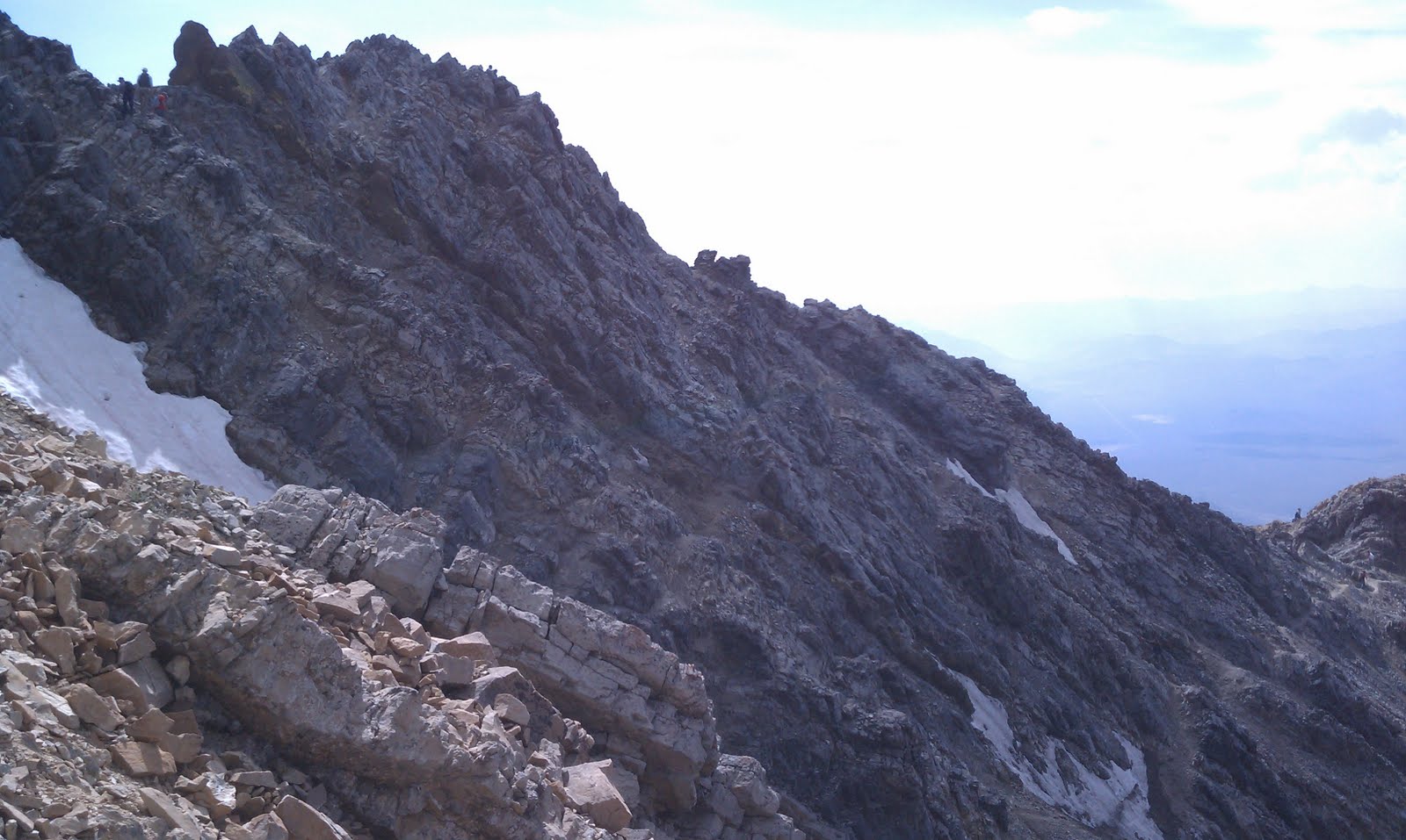
I had brought a good topographic map that showed that one side of the range was essentially a steep cliff, the other side however seemed to have much more spaced out contour lines suggesting much less inclination, by a factor 3-5. However as can barely be seen from the photo below, the east side really is extremely steep...


And 5 times less steep on the other side is like going from 88 degree inclination to 80. Meaning still steep as heck as can be seen from the photo below which is taken on the same spot as the one above! but in the opposite direction. The path was still fairly wide at 5-10 feet when counting the surrounding rocks, but that is still narrow if one happen to trip sideways...


Nothing bad happened on the ascent nor decent though. And after a about 2 miles crisscrossing but with a mild gradient upwards, a plateau presents itself and the mountain flattens out somewhat as can be seen in the picture below of the final stretch.


And all of a sudden the Smithsonian hut appears close to the peak. It is a really significant landmark, but you will not be able to see it from far down, nor before getting within a few hundred meters of it...


The picture below shows the approaching path that follows the small peaks from the south. The trail itself is also visible on the relatively flat part of the left side (click to enlarge photo).


The approaching valley of the Whitney trial is here seen together with pinnacle ridge going out from the left to right, ending in Thor peak.


The top shot was made in the Captain Morgan pose. Although I could not find my barrel of Rum, which was probably good, I would have loved a celebratory drink, but with 5h to go down, that would likely not have been the best of ideas. So instead it was fresh banana, energy bar, dried banana and some energized water that I feasted on. I should mention that the top was quite crowded at close to 30 people, and that continued from the last part of the ascent to about 12 000 ft on the decent at Trail Camp where the crowd then thinned out quickly.

Being a 22miles round trip (35km) the decent took me down at a good pace, although my legs started protesting with 2 hours to go and my feet started complaining especially the last hour, but rather than then the first hour when hiking for 12h! As can be seen below my taped and bruised feet were quite thrilled to be out of their shoes later in that evening.


This bottle was emptied around 12000 feet, and at the hotel at 3000 feet elevation the increased atmosperic pressure had done a good job illustrating just how much less air there is at higher altitudes, and adding 5000ft more elevation difference would show the difference from my home state Michigan to the top of Mt Whitney...


Lots of snow in the surroundings, but not too much on the path. 22miles round trip (35km), which took just under 12h to complete.

Full update to come.

Stats:
State: California
High point: Mount Whitney
Elevation: 14 494 ft (4 417 m)
Date: July 14, 2011
Total elevation to date: 149 668 ft (45 618 m)
Access: Hike, class 1 (up to class 4 exposure) 12h round trip minimum. 22 mi/35km round trip.
Difficulty rating (of 10): 7
Potential Difficulties: